Route distance: 34,870 km on foot
Estimated time: 7h 45' on foot
Maximum height: 781 m on foot
Minimum height: 294 m on foot
Accumulated gradient: On foot, 2.292 m (uphill: +1.248 m; downhill: -1.044 m)
Distance Coll de Prenafeta's variant: 2,777 km
Distance Sant Joan's variant: 9, 069 km
** This tour can be done in two stages: Santes Creus to Prenafeta or even Montblanc and then continue to the monastery of Poblet.
*** If you arrive by public transport in our territory, it is advisable to start from Montblanc.
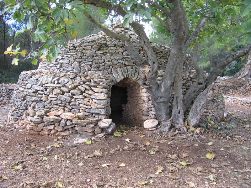
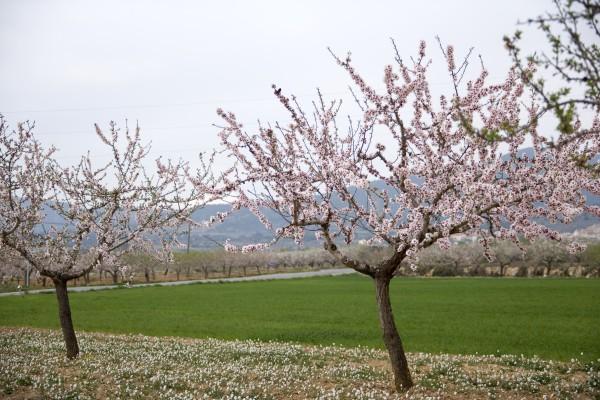
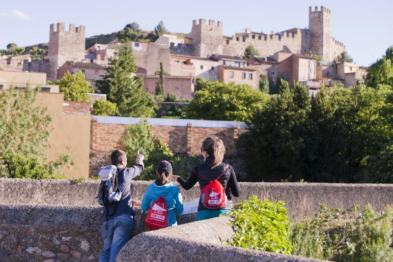
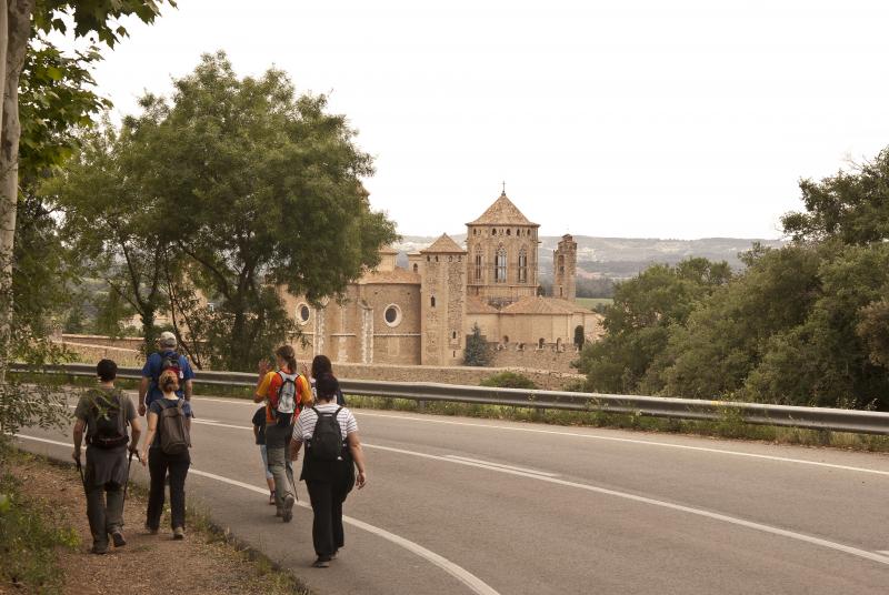
We depart from Santes Creus monastery located located in the municipality of Aiguamúrcia, in the Alt Camp region, along the road of Aiguamúrcia TV-2006 and continue along a path up with loose stones. We walk among pine forests, and later connect with the Route Capona a flat route that runs between crop fields where almond trees predominate. Of particular note are dry stone constructions of great interest as the Cossiol. We cross the road Cabra del Camp TV-2004 to enter the next town, Pla de Santa Maria. We cross the old town to continue along the ring road in the valley. We continue along an ancient road, climb climb to Figuerola del Camp. Through the village by steep streets to take the path dels Horts with gentle climb to the foot of the mountain. Later the road is very rocky and difficult to walk. We go into the forest Rector of great natural value with magnificent specimens of holly. We left the variant Prenafeta mountain bike and continue along the forest trail to the coll of Planota de Faló (776 m), the highest point of this section. Now we begin to go down to the old town of Prenafeta, at the foot of the castle, with stretches of paved path moderate descent through a magnificent forest of oaks. From Prenafeta continue along the main street to the church and turn right down the only road crossing. We pass in front of a house and later by the cemetery and cross a small forest. After the intersection with the chapel of Santa Ana pass through a wooden bridge that crosses the ditch of San Miguel. From here the road passes between fields and planted vineyards. We reach Montblanc, capital of the Conca de Barbera, the cemetery and a small industrial area, pass under the railway bridge down the old bridge to find the walls of Montblanc.
We depart from Montblanc by Dr. Folch Avenue to the intersection of the street of Joan Amades following the right. We continue along a forest track to a crossroads where we will continue on the path of our right, which goes into the Prades Mountains and the Natural Park of Poblet Forest. This trail leads to the hermitage of Sant Joan (700 m), the highest point of this section. Steep stretch. From Sant Joan the trail is mostly flat with some small steep slope. The entire stretch circulates within a mixed forest of oaks, pines, ... high natural and scenic value. At km 6 we find the fork to the chapel of the Holy Trinity. Later we arrive at the coll of Vena where we start to go down. The first section is equipped with stairs and railings to overcome the steep slope. The rest of softer until you reach the monastery of Poblet, in the municipality of Vimbodí-Poblet low path. From the urbanization of Les Masies, in the municipality of Espluga de Francoli, to the monastery driving on the road.
BIKE RIDE
They are provided two variants for cyclists to avoid the path that goes from the Coll de Prenafeta to Prenafeta (2,771 km) and the climb to the hermitage of Sant Joan for cyclists from Montblanc along the path of Tossa or also GR171 (9,069 Km).
We stretch shabby in BTT:
From Figuerola del Camp follow the path dels Horts. Later the road is very rocky and full of streaks. To avoid loading the bike in this section is proposed to follow the path of Coloma from Figuerola. It is a path marked from Figuerola and soft climbing along a track with good firm to the coll of Planota del Faló (776 m) where you have to follow the directions of the walking trail to Prenafeta. Careful about the fall!
DOWNLOAD:
APPROXIMATE DISTANCES:
BY FOOD:
- Km 0,000 - Monastery of Santes Creus ( Aiguamúrcia)
- Km 3,775 - El Cossiol ( El Pla de Santa María)
- Km 8.230 - El Pla de Santa Maria
- Km 11.270 - Figuerola del Camp
- Km 16.050 - Old vilage, Prenafeta ( Montblanc)
- Km 16.700 - Prenafeta ( Montblanc)
- Km 23.760 - Montblanc
- Km 27.900 - Hermitage of Sant Joan ( Montblanc)
- Km 34.100 - Las Masies (l'Espluga de Francolí)
- Km 34.870 - Monastery of de Poblet ( Vimbodí-Poblet )
BTT:
- Km 0,000 - Monastery of Santes Creus ( Aiguamúrcia)
- Km 3,775 - El Cossiol ( El Pla de Santa María)
- Km 8.230 - El Pla de Santa Maria
- Km 11.270 - Figuerola del Camp - ATTENTION ! SECTOR IN POOR CONDITION, it is recommended to go the Coll de la Coloma.
- Km 17.400 - Prenafeta ( Montblanc)
- Km 24.400 - Montblanc
- Km 25,200 - Variant BTT Sant Joan , link to GR171 and Saint James Way in Catalonia
- Km 31.650 - L'Espluga de Francolí
- Km 34.030 - Les Masies (l'Espluga de Francolí)
- Km 35.600 - Monastery of Poblet ( Vimbodí-Poblet)
WATER POINTS:
In addition to the villages we will go through, you will find drinking water once you pass Figueroladel Camp and in the hermitages of Sant Joan and the Holy Trinity. Just before arriving at Poblet Monastery we will find the Abat Siscar fountain (three mineral water fountains: ferruginous and magnesium).
ACCOMMODATIONS:
Accommodations that relate to those involved with the CARNET 6T and you will find in this section. Other accommodation click HERE.
In Santes Creus:
- Hostel Pere el Gran - Tel. 695 18 68 73 - www.albergpereelgran.cat
- Hotel -Restaurant Grau HR ** - Tel. 977 63 83 11- www.hostal-grau.com
In Montblanc:
- Hotel Viaurèlia H ** - Tel. 977861790 - 977861791 - www.hotel-viaurelia.com
- Apartamentos El Jaç (APT) - Tel. 977 86 32 65 - www.eljacmontblanc.com
Near Montblanc, in Vilaverd:
- Hotel Cal Maginet (H ***) - Tel. 977876015/639131574 - www.calmaginet.cat
- Mas les Talaveres (CPI) - Tel. 658 65 41 79 - http://webfacil.tinet.cat/mastalaveres
In Poblet (Vimbodí-Poblet):
- Hospedería de Poblet - Tel. 977 87 12 01. http: //hostatgeriadepoblet.cat/
- Restaurante y Apartamentos Masia Sagués (to 800m to monastery) - Tel. 977 87 00 63 / 659 374 940. http://www.masiasagues.com/
In Les Masies, Espluga de Francolí:
- Albergue Jaume I - Tel. 977 87 03 56 - www.xanascat.cat
- Hotel Masia Cadet (H ***) - 977 87 08 69 - www.masiadelcadet.com
- Hotel Monasterio H *** - Tel. 977 87 00 58 - www.hotelmonestir.com
- Masía Font de l'Oca (M) - Tel. 639 32 80 70 - www.ocamasia.com
In l'Espluga de Francolí:
- Fonda Ocell Francolí. Tel. 977 87 12 16 - http://www.ocellfrancoli.com/
RECOMENDATIONS:
- This route is apt for any participant who is used to hiking as it does not entail any more difficulty than the distance to be covered and moderate gradients.
- The route should be designed, more or less, in stages and taking into account the number of days you have available, your goals and your physical preparation. The route can be done in both directions.
- Cyclists have 4 bypasses that have been planned for the most complicated parts, but they still require a certain amount of effort and physical preparation.
- saddlebags are not recommended. If you want you can contract the baggage, bike...transfer service.
- You should get weather forecast information.
- You should take enough eater for the route and drink regularly.
- You should usesun cream.
- You should book accommodation.
- There are many villages with no shops, restaurants......to have a snack.
- Many establishments are closed on Mondays.
- Many establishments do not accept credit cards. There are cash machines in: El Pla de Santa Maria, Montblanc, l'Espluga de Francolíand in Pont d'Armentera.
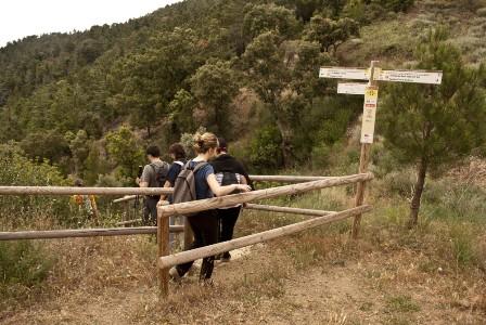
- The itinerary is signposted with the characteristic GR white and red signs, with directional post that are very clearly identified that, moreover, give information about the place and the altitude.
- You should respect the environment and the norms established by Poblet Nature Park and the by the owners of properties that you pass through.
- Emergency telephone number : 112.
- For any suggestions, incidents or anomalies, please contact: info@larutadelcister.info and by phone on: 977 87 12 47.